-
Map Shows Heat Wave Zone Spread Into Five New States - May 26, 2024
-
A portion of Mulholland Drive, damaged by mudslides in winter storms, reopens - May 26, 2024
-
‘Maybe You Don’t Want to Win’ - May 26, 2024
-
Donald Trump Putting Law Enforcement in Danger: Attorney - May 26, 2024
-
Avoid the waters of these 5 L.A. County beaches this holiday weekend, public health officials say - May 26, 2024
-
Bawdy Comedy ‘Anora’ Wins Palme d’Or at Cannes Film Festival - May 26, 2024
-
Map Shows Heat Wave Zone Spread Into Five New States - May 26, 2024
-
Azusa police arrest suspected slingshot-wielding vandal - May 25, 2024
-
Donald Trump Hammers Judge Ahead of Jury Instructions - May 25, 2024
-
Sometimes U.S. and U.K. Politics Seem in Lock Step. Not This Year. - May 25, 2024
Map Shows Heat Wave Zone Spread Into Five New States
A National Weather Service (NWS) moderate heat alert expanded to five new states in the south and south-eastern United States between Wednesday and Saturday, according to maps published by the federal agency.
The moderate alert was extended to Georgia, Oklahoma, New Mexico, North Carolina, and South Carolina over the three-day period. However, during this time, it was also withdrawn from ten states, primarily in the north-east. These were Ohio, Michigan, Maine, Vermont, New Hampshire, Rhode Island, Connecticut, New Jersey, Delaware and Maryland.
Much of southern and central United States have been rocked by bad weather in recent weeks, with President Joe Biden issuing a disaster declaration for parts of Texas whilst on Thursday a tornado ripped through Olustee, Oklahoma. Over the Memorial Day weekend, the NWS is forecasting more thunderstorms across the central Plains even as there is an ongoing tornado warning for Kansas and Oklahoma.
According to the NWS’ official website, a moderate or orange heat warning is a level that “affects most individuals sensitive to heat, especially those without effective cooling and/or adequate hydration.”

Brandon Bell/GETTY
As a result, this level means “impacts possible in some health systems and in heat-sensitive industries.”
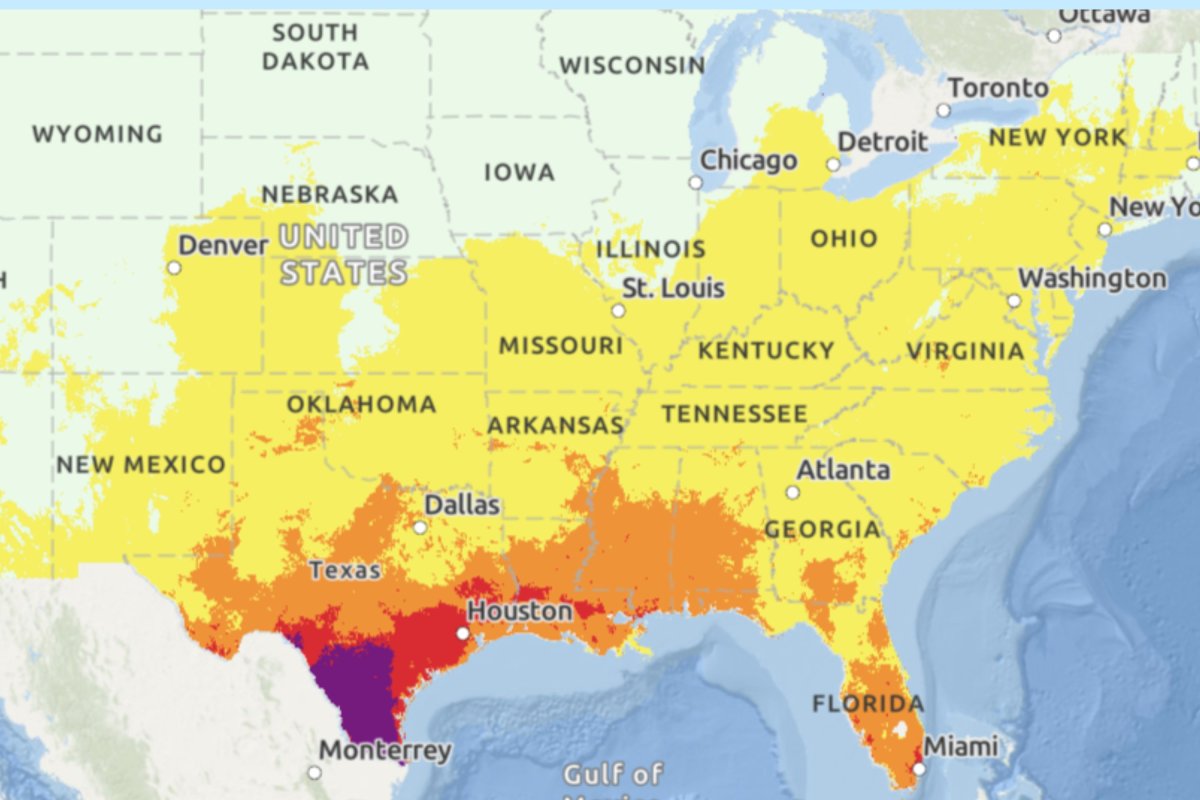
As of Saturday, the orange alert is in place for large chunks of Texas, Louisiana, Mississippi, Alabama, Georgia and Florida. It also applies to smaller sections of New Mexico, Oklahoma, Arkansas, Tennessee, South Carolina, North Carolina, Virginia, West Virginia, Pennsylvania and New York.
The highest NWS heat warning is “extreme,” shown on the map by the color purple, which is only in place for a section of southern Texas on Saturday.
According to the agency, “this level of rare and/or long-duration extreme heat with little to no overnight relief affects anyone without effective cooling and/or adequate hydration. Impacts likely in most health systems, heat-sensitive industries and infrastructure.”

National Weather Service
The second highest tier NWS warning is red, meaning “major,” which is in place for more of southern Texas along with patches of Louisiana, and some small areas in southern Mississippi. The NWS states: “This level of heat affects anyone without effective cooling and/or adequate hydration. Impacts likely in some health systems, heat-sensitive industries and infrastructure.”
This is followed by the orange “moderate” tier, then the yellow “minor” tier which covers almost all of the eastern U.S. not under a higher warning, up to New Hampshire, along with most of the central and southern U.S. to some degree including California, Nevada and Utah.
The NWS states: “This level of heat affects primarily those individuals extremely sensitive to heat, especially when outdoors without effective cooling and/or adequate hydration.”
The lowest green tier applies to states in the north, including Oregon, Idaho, the Dakotas, Minnesota, and Maine. According to the NWS, this means there is “little to no risk from expected heat.”
Uncommon Knowledge
Newsweek is committed to challenging conventional wisdom and finding connections in the search for common ground.
Newsweek is committed to challenging conventional wisdom and finding connections in the search for common ground.
Source link


