-
Worsening wind forecast brings new L.A.-area fire risk beginning Monday - 3 hours ago
-
TikTok ‘Restoring Service’ After Donald Trump Shares New Plan - 3 hours ago
-
Jake Sullivan, White House National Security Adviser, Reflects on China Policy - 8 hours ago
-
Jimmy Butler Issues With Heat Stemmed From Lack of Big Trades - 8 hours ago
-
Indigenous practices mitigated Eaton fire damage, Tongva leaders say - 9 hours ago
-
UFC 311 Recap: Islam Makhachev and Merab Dvalishvili Retain Titles in Los Angeles - 14 hours ago
-
California attorney general says bidding wars not exempt from price-gouging rules - 16 hours ago
-
Winter Storm Is Bringing at Least 6 Inches of Snow to the Northeast - 18 hours ago
-
Texans’ DeMeco Ryans Seemingly Takes Shot at NFL Officiating Following Loss to Chiefs - 19 hours ago
-
5 major banks offer mortgage relief in fire-ravaged L.A. areas, Newsom says - 22 hours ago
Worsening wind forecast brings new L.A.-area fire risk beginning Monday
The Santa Ana wind forecast for Southern California has worsened, and forecasters now expect to issue a red flag fire weather warning starting Monday, with the “risk of large fire growth” should ignitions occur.
“This is now a strong Santa Ana wind event and extreme fire weather,” said Rose Schoenfeld, meteorologist with the National Weather Service office in Oxnard, a deterioration of expected weather conditions from an earlier forecast.
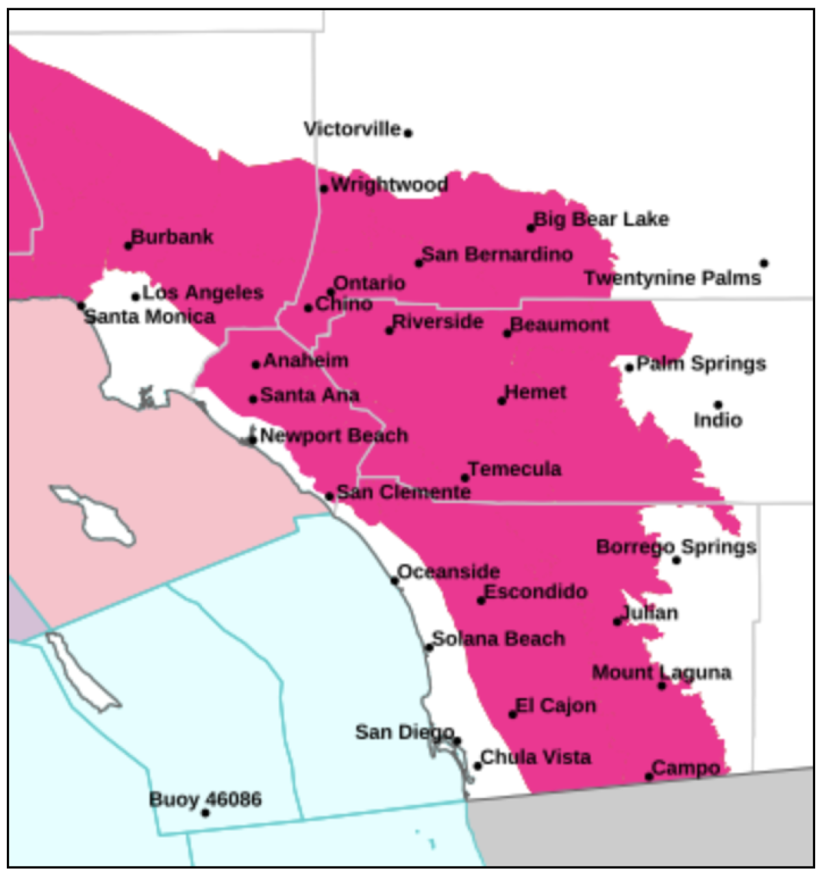
A red flag warning — indicating critical fire weather conditions and rapid fire spread with any new ignition — could go into effect for wide swaths of the counties of Los Angeles, San Diego, Orange, Riverside, San Bernardino and Ventura starting at 10 a.m. Monday and continuing through 10 p.m. Tuesday.
Over the weekend, firefighters raced against the new threat of powerful winds to increase containment of the wildfires still burning in Pacific Palisades and Altadena — areas that fall under the red flag warning.
As of Sunday morning, the Palisades fire, which has burned more than 23,700 acres, destroyed more than 4,900 structures and has killed at least 10 people, was 52% contained, according to Cal Fire. The Eaton fire, which has burned more than 14,000 acres, destroyed more than 9,300 structures and killed at least 17 people, was 81% contained.
There are still 27 people reported missing: 20 from the Eaton fire and seven from the Palisades, according to the Los Angeles County Sheriff’s Department.
Just over 2,700 federal and state fire personnel continued to battle the Eaton fire on Sunday — slightly less than the day before as some fire crews were relieved from duty. L.A. County Fire Department public information officer Carlos Herrera said officials will continue to release firefighters – who have come from all around the country as well as Canada and Mexico – as containment increases.
But the department will remain in communication with weather experts to staff appropriately, “especially in Altadena in Mt. Lowe and Mt. Wilson — some spots where we’re looking on getting containment,” Herrera said. “We have plenty of resources.”
Other regions affected by the warning include Santa Monica and the San Gabriel Valley. Areas outside the red flag warning zone include the L.A. Basin, such as downtown L.A., Torrance and Long Beach, and coastal San Diego and Orange counties.

A red flag warning — indicating a high risk for critical fire weather conditions and rapid spread with any new ignition — could take effect Monday for large portions of Los Angeles and Ventura counties.
(National Weather Service)

Red flag warnings, which indicate critical fire weather and rapid spread should ignition occur, are expected to be in effect for large swaths of Los Angeles, San Diego, Orange, Riverside, San Bernardino and Ventura counties starting Monday.
(National Weather Service)
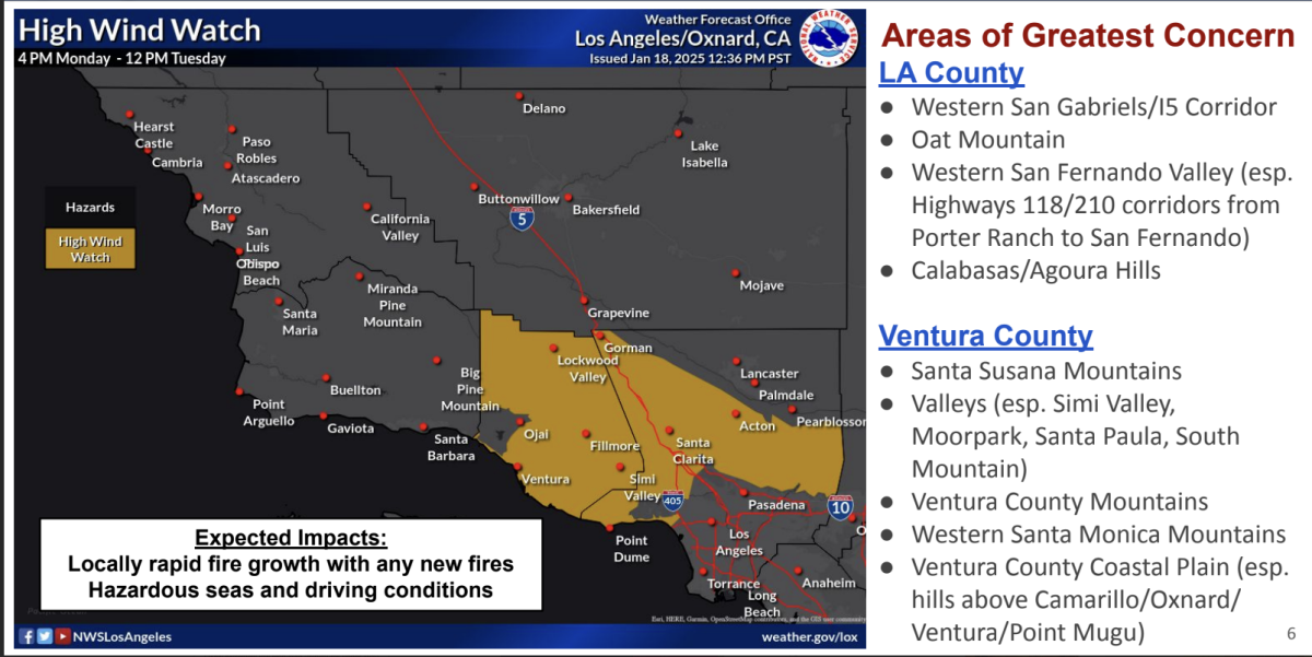
With this being more of a traditional Santa Ana wind event, with winds coming out of the east to northeast, Ventura County will be an area of great concern.
In the area of highest risk this week, sustained winds from the east and northeast could reach 25 mph to 40 mph, with gusts of up to 65 mph, across the coast and valleys in a traditional Santa Ana wind corridor — which stretches to the southwest, from Palmdale to Santa Clarita and Ventura on the way to the coast.
In the mountains and foothills, sustained winds could be between 30 mph to 45 mph, with gusts as high as 60 mph to 80 mph. Gusts can become damaging at around 65 mph.
In L.A. County, areas of greatest concern include the western San Fernando Valley, Calabasas, Agoura Hills, the western San Gabriel Mountains and the Grapevine section of Interstate 5.

(National Weather Service)
Winds are expected to be strongest from Monday night through Tuesday morning.
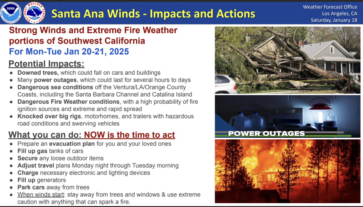
“This is a time to act, yet again,” Schoenfeld said, warning that people should be prepared to evacuate and take steps including preparing medication, putting fuel in cars, looking at evacuation routes and signing up for emergency notifications from local authorities.
That also means securing loose outdoor items, like patio furniture; adjusting travel times between Monday night and Tuesday morning; charging up electronics, flashlights and battery packs; filling up emergency generators; and moving cars from trees that appear fragile, Schoenfeld said.
Experts warn people against keeping certain items within 5 feet of your home, such as outdoor furniture, umbrellas, garbage and recycling bins. Getting rid of all dead or living weeds from this area is also a good idea, as is clearing gutters, roofs, decks, porches and stairways of flammable materials, like leaves and needles.
“And then when wind does start, stay away from trees, windows. And use extreme caution, again, with anything that could start a fire,” Schoenfeld said.

(National Weather Service)
Gusts could be so powerful they may knock over big rigs and motor homes and trigger power outages that could last days, the weather service said.
At this point, forecasters are not suggesting there’s a strong chance they’ll issue a “particularly dangerous situation” enhancement of the red flag warning, which indicates an extreme red flag warning. At this time, this Santa Ana wind event doesn’t look like it’ll be as extreme as the Jan. 7–8 event, when severe winds were forecast for a much wider area, including through the L.A. Basin.
“This event has a different area of focus. More Ventura County-focused,” Schoenfeld said, and in L.A. County, a focus more on the western part of the county, and at its highest elevations.
Still, the risk of critical fire behavior is expected to be high with the strong Santa Ana winds across much of the region, combined with extraordinarily dry air and parched vegetation, desiccated from eight months of virtually no rain.
Very dry conditions are expected all week, with the driest on Tuesday, the weather service said. Relative humidity could fall to as low as 5% in the western San Fernando Valley, Santa Clarita, Oxnard, Thousand Oaks and Fillmore.
Fire weather concerns will persist through the week, Schoenfeld said, with more Santa Ana winds possible by Thursday. The weather service could end the red flag warning on Tuesday, or could extend it through Thursday.
Santa Ana winds are powerful winds that develop when high pressure over Nevada and Utah sends cold air screaming toward lower-pressure areas along the California coast. The Santa Ana wind season is generally from October through March.
The air dries out, compresses and heats up as it hits the mountains ringing Southern California, and flows downslope from the high deserts — from the northeast — over California’s mountains and through canyons, drying out vegetation as the wind gusts through.
Looking forward, there is some hope of rain coming in about a week. But, at this point, it doesn’t appear to be the kind of soaking that would be needed to end the fire season, Schoenfeld said.
There’s around a 20% to 30% chance of rain, especially between Jan. 25–27, Schoenfeld said, and a 10% chance of thunderstorms.
“It doesn’t look like a really thoroughly wetting rain for a broad scope of the area,” Schoenfeld said. “That’s honestly bad news for our fire weather season going forward.”
There’s also no strong indication of a moderate atmospheric river headed toward L.A. But the slight chance of thunderstorms does raise concerns about the potential for landslides and mudflows in recently burned areas.
Southern California has been stuck in an unusually persistent pattern of no rain combined with the periodic return of Santa Ana winds so far this winter. The region is stuck in one of the driest — if not the driest — starts to the winter in recorded history.
Downtown L.A. has seen only 0.16 of an inch of rain since Oct. 1, the start of the water year. That’s only 3% of the average for this point in the water year, which is 5.89 inches for downtown. Downtown L.A.’s annual average for precipitation is 14.25 inches.
It is highly unusual for winter rains to start this late, which puts Southern California at high risk for fire weather. January is the month where Santa Ana winds are most common and can be the strongest of the season.
Lately, the jet stream’s path has been far from California, taking a route from the Pacific Ocean to northern British Columbia and Alaska, denying California storms, said Alex Tardy, meteorologist with the National Weather Service office in San Diego.
It’s a similar weather pattern to the one seen in January 2022, when it hardly snowed in the Sierra Nevada.
“It’s a complete block. So everything misses California,” Tardy said of winter storms. “It seems like we can’t catch a break.”
Aggravating the situation is the cold air over Canada that’s dominating the weather pattern, Tardy said, and is keeping California on the dry, windy side of the jet stream, not on the side providing precipitation. That’s setting up the configuration in which high pressure will build up over Nevada and Utah, sending wind toward Southern California, in search of lower pressure off the coast.
Times staff writer Melody Gutierrez contributed to this report.
Source link


